
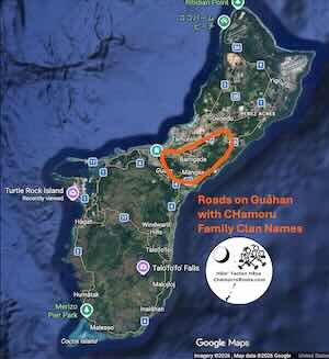
So last night, I was reviewing some genealogy information that led me to click on a link and open a map focused on the central part of Guåhan. As I looked at the map what stood out was the many roads with CHamoru family clan names. I’m sure there are probably more, but I noted at least 42 within the orange circle I highlighted on this map, which primarily included the villages of Maite, Mongmong, Toto, Barrigada and Mangilao.
Can you help the CHamoru Roots Genealogy Project identify these clan name roads/place names within Guåhan, Luta, Tini’an, and Sa’ipan (Island, village, clan name road/place name)?
| Clan Name Roads |
| Abing |
| Anonas |
| Aragon |
| Balaku |
| Bejong |
| Biang |
| Bibik |
| Binadu |
| Bodoki |
| Bonik |
| Capili |
| Casimiru |
| Chala |
| Clara |
| Deda |
| Dero |
| Dicta |
| Dinong |
| Dodo |
| Duendes |
| Ella |
| Endon |
| Guspat |
| Kadi |
| Kaila |
| Kichu |
| Kondo |
| Lalo |
| Nando |
| Paquito |
| Paterno |
| Peperu |
| Potu |
| Pulan |
| Red |
| Robat |
| Sam |
| Spotsa |
| Taluba |
| Tenbat |
| Tuba |
| Ungkulu |